Wiki-Hurricanes Forecasting Center Samples
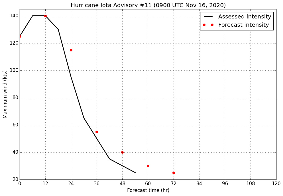
Hurricane Iota
Advisory 11 / 4:00 AM EST Monday, November 16, 2020
125 kt, 932 hPa
Iota has experienced rapid deepening and intensification since last night. An Air Force reconnaissance mission into the hurricane found 700 hPa winds of 134 kt and SFMR winds of 121 kt. Additionally, they observed an unprecedented 10 hPa drop in pressure between two center passes approximately an hour apart. Intense lightning and hail was also reported in the inner core of the hurricane. Iota maintains an impressive satellite appearance for a category 4 hurricane, and recent infrared imagery shows that the central dense overcast continues to expand and cool, with an increasingly warm eye apparent. A combination of these data suggest an initial intensity of at least 125 kt. With the knowledge that winds may have caught up to the pressure falls, and further deepening is possible since the eye penetrations a few hours ago, winds inside the hurricane may in actuality be even higher than this assessed intensity.
As stated in the previous advisory, the intensity evolution of Iota comes down to internal core dynamics. The hurricane's surrounding environment remains straightforwardly conducive for further intensification as it sits atop 28-29C waters, with adequate mid-level moisture, and an expansive upper-level anticyclone providing excellent ventilation with little wind shear. SHIPS suggests there is around a 50% of 20 kt intensification over the next 12 hours, indicating that there is sufficient time for Iota to become a category 5 hurricane before landfall. Beyond this, a discussion of model forecasts is of little use as dynamical model initializations are far behind the current intensity evolution of Iota. With no indications from the last reconnaissance flight of any developing outer eyewall, only further rapid intensification can be forecast at the moment, and a category 5 hurricane is explicitly depicted in the intensity forecast. The caveat remains that internal dynamics are hard to predict, and that the development of an eyewall replacement cycle could halt this intensification at any time before landfall in the next 18-24 hours. Regardless of the specifics, Iota is expected to be a very intense hurricane at landfall with serious impacts. Rapid weakening should ensure thereafter, with degeneration to a remnant low on day 3, and dissipation forecast by day 4.
Iota is tracking just north of west this morning as broad mid-level ridging to the north directs the storm. It should continue on this path until it meets the Nicaraguan coastline in 18-24 hours. Ridging to the northwest is forecast to strengthen, directing Iota more to the west and eventually west-southwest after landfall, where it is expected to dissipate inland over Central America.
FORECAST MAX WINDS
INIT 16/0900Z 125 KT 145 MPH
12H 16/1800Z 140 KT 160 MPH
24H 17/0600Z 115 KT 130 MPH...INLAND
36H 17/1800Z 55 KT 65 MPH...INLAND
48H 18/0600Z 40 KT 45 MPH...INLAND
60H 18/1800Z 30 KT 35 MPH...INLAND
72H 19/0600Z 25 KT 30 MPH...POST-TROP/INLAND
96H 20/0600Z...DISSIPATED |
|
 |
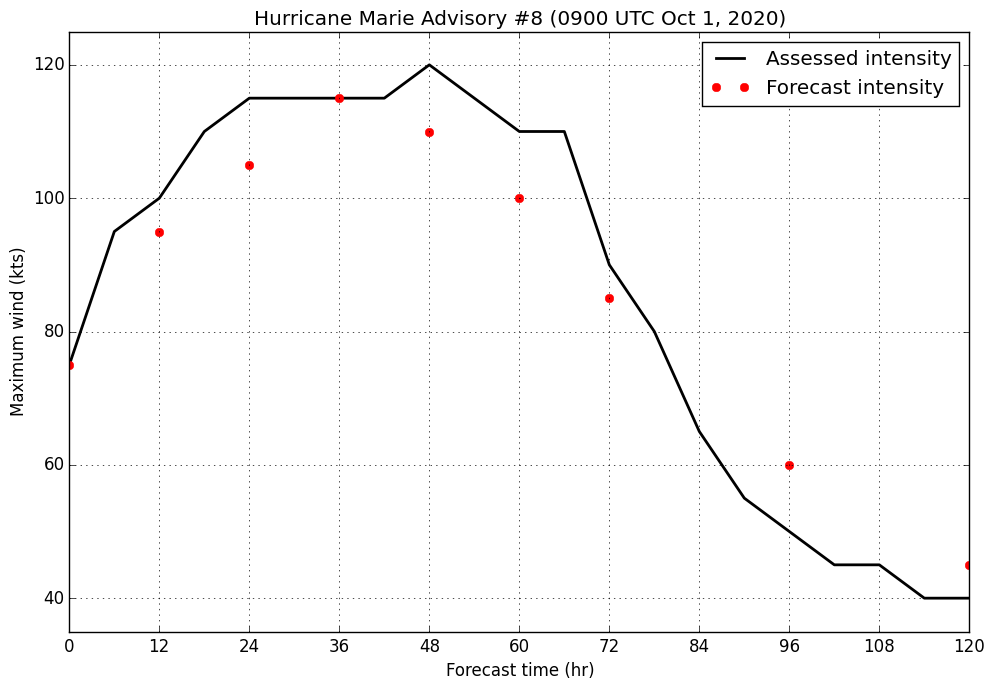
Hurricane Marie
Advisory 8 / 2:00 AM PDT Thursday, October 1, 2020
75 kt, 981 hPa
Marie has resumed strengthening this morning. Vigorous bursts of deep convection have contributed to an expansion and cooling of the hurricane's central dense overcast, and spiral banding in the western semicircle is returning after it mostly dissipated yesterday. The hurricane's structure has improved on microwave as seen in a 0425z GMI pass, which indicates an almost closed eyewall. Rising satellite intensity estimates and subjective improvement in the structure and presentation lead to raising the initial intensity to 75 kt for this advisory, although this could be somewhat conservative.
Light easterly shear persists over Marie this morning. This is not expected to hinder the hurricane much as it is supported by warm sea surface temperatures near 28C and a moist mid-level environment for the next 36 to 48 hours. The storm's structure is primed for significant intensification, which it has likely already begun. With model guidance continuing to support the same scenario of a strong category 3 or minimal category 4, the updated intensity forecast now explicitly indicates Marie becoming a category 4 hurricane, and the peak has been brought forward slightly. After about 36 hours, sea surface temperatures will not be as supportive and Marie will begin to move into a more dry and stable environment, although wind shear should be near the lowest it is forecast to be. This will induce some slow weakening before the hurricane moves into marginal and unsupportive waters and wind shear begins to increase on day 3. This will initiate a steady weakening trend which persists for the remainder of the forecast period.
Marie is tracking west this morning, with this motion expected to continue through today, before its position on the southwest side of broad mid-level ridging will steer it west-northwest. This motion may turn more northwesterly briefly as a mid-level cut-off low passes north of the hurricane, but motion is likely to generally remain west-northwest until the end of the forecast period, when Marie is anticipated to turn toward the north as the ridge slides south of the storm and it begins to interact with another mid-level low to its northwest.
FORECAST MAX WINDS
INIT 01/0900Z 75 KT 85 MPH
12H 01/1800Z 95 KT 110 MPH
24H 02/0600Z 105 KT 120 MPH
36H 02/1800Z 115 KT 130 MPH
48H 03/0600Z 110 KT 125 MPH
60H 03/1800Z 100 KT 115 MPH
72H 04/0600Z 85 KT 100 MPH
96H 05/0600Z 60 KT 70 MPH
120H 06/0600Z 45 KT 50 MPH
|
|
 |
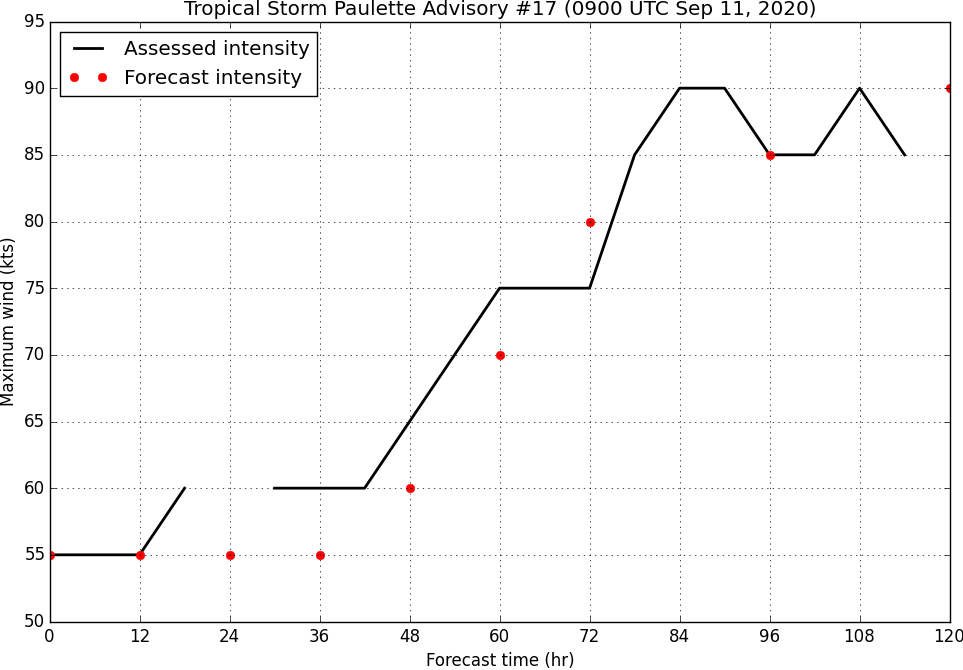
Tropical Storm Paulette
Advisory 17 / 5:00 AM EDT Friday, September 11, 2020
55 kt, 991 hPa
Explosive convective bursts and expansive upper-level outflow continue to support Paulette in spite of the strong southwesterly wind shear imparted by a tropical upper-tropospheric trough. A few hours ago, the storm's low-level center was mostly exposed on infrared satellite imagery, but in more recent frames, the vigorous deep convection has migrated back south over the center. The initial intensity is held at 55kt for this advisory.
Strong wind shear of around 35-40kt continues to affect Paulette this morning, with it expected to continue for the next 24 hours or so before quickly abating in conjunction with the fracturing of the TUTT and the development of an upper-level anticyclone over the storm. Until that occurs, Paulette is expected to remain at a near constant intensity or even weaken slightly. It should be noted that there is now very little model guidance, dynamical or statistical, that shows weakening of the storm, although that does not preclude slight or brief bouts of weakening over the next day or so. With the introduction of a favorable environment beyond about 36h, Paulette is expected to resume strengthening in a favorable environment with 28-29C sea surface temperatures and low shear. Model guidance is in good agreement that Paulette should become a hurricane of at least category 2 intensity sometime on day 4, with general agreement that significant strengthening should occur on days 3 and 4. As a result, the highest rate of intensification in the forecast has been moved forward into that time frame, making Paulette a hurricane early on day 3.
Paulette continues to move just north of west-northwest this morning. This motion is expected to continue for the next 36 to 48 hours or so before turning more toward the west as mid-level ridging slides north of the cyclone. As the ridge passes toward the east with an impinging mid-latitude trough, Paulette should begin to round the ridge and turn north on day four, near Bermuda. This motion should turn quickly toward the northeast as the system enters the mid-level westerlies on day five.
FORECAST MAX WINDS
INIT 11/0900Z 55 KT 65 MPH
12H 11/1800Z 55 KT 65 MPH
24H 12/0600Z 55 KT 65 MPH
36H 12/1800Z 55 KT 65 MPH
48H 13/0600Z 60 KT 70 MPH
60H 13/1800Z 70 KT 80 MPH
72H 14/0600Z 80 KT 90 MPH
96H 15/0600Z 85 KT 100 MPH
120H 16/0600Z 90 KT 105 MPH
|
|
 |
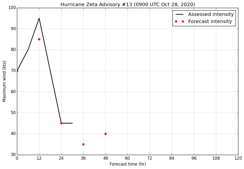
Hurricane Zeta
Advisory 13 / 5:00 AM EDT Wednesday, October 28, 2020
70 kt, 982 hPa
Air Force reconnaissance finds Zeta a hurricane this morning. On infrared satellite, significant improvement in presentation is also noticeable. Deep convection has expanded and wrapped most of the way around the center since the previous advisory and a large, warm eye has been intermittently present. The Air Force plane in the system measured 77 kt 700 hPa flight-level winds and 68 kt SFMR winds, supporting an initial intensity of 70 kt. Dropsonde observations indicate Zeta has a fairly low central pressure, 982 hPa.
Zeta is expected to continue to strengthen at least for the next six hours or so as it takes advantage of an environment of low-wind shear, modest moisture, and warm sea surface temperatures. Given the storm's structure and model guidance, this is expected to be significant. The intensity forecast depicts a category 2 hurricane at peak in 6-12 hours, based on HWRF guidance which has verified well for the storm thus far. This is also supported by much of the rest of the dynamical guidance which supports continued intensification. As the system approaches the coast, cooler, but still supportive ocean temperatures, and increasing shear are likely to lead to a levelling off intensity as favorable upper-level divergence in the entrance region of an upper-level jet streak acts to maintain the system. Once the storm makes landfall, this will also act to maintain stronger winds than typical inland tropical cyclones, and Zeta is expected to regain some strength as it moves back over water on day three, before being absorbed into a frontal zone.
Zeta is moving north-northwest this morning as it begins to feel the influence of the mid-to-upper level cyclone over the southwestern US and Southern Plains. Throughout the day today the hurricane should turn north and then north-northeast, putting it on the southeastern Louisiana coastline in 12-18 hours and moving into Mississippi shortly thereafter. By day two, having moved well inland, the storm should turn northeast in the mid-latitude westerlies, emerge off the mid-Atlantic coast before dissipating.
FORECAST MAX WINDS
INIT 28/0900Z 70 KT 80 MPH
12H 28/1800Z 85 KT 90 MPH
24H 29/0600Z 45 KT 50 MPH...INLAND
36H 29/1800Z 35 KT 40 MPH...INLAND
48H 30/0600Z 40 KT 45 MPH...INLAND/POST-TROP/EXTRATROP
60H 30/1800Z...DISSIPATED
|
|
 |
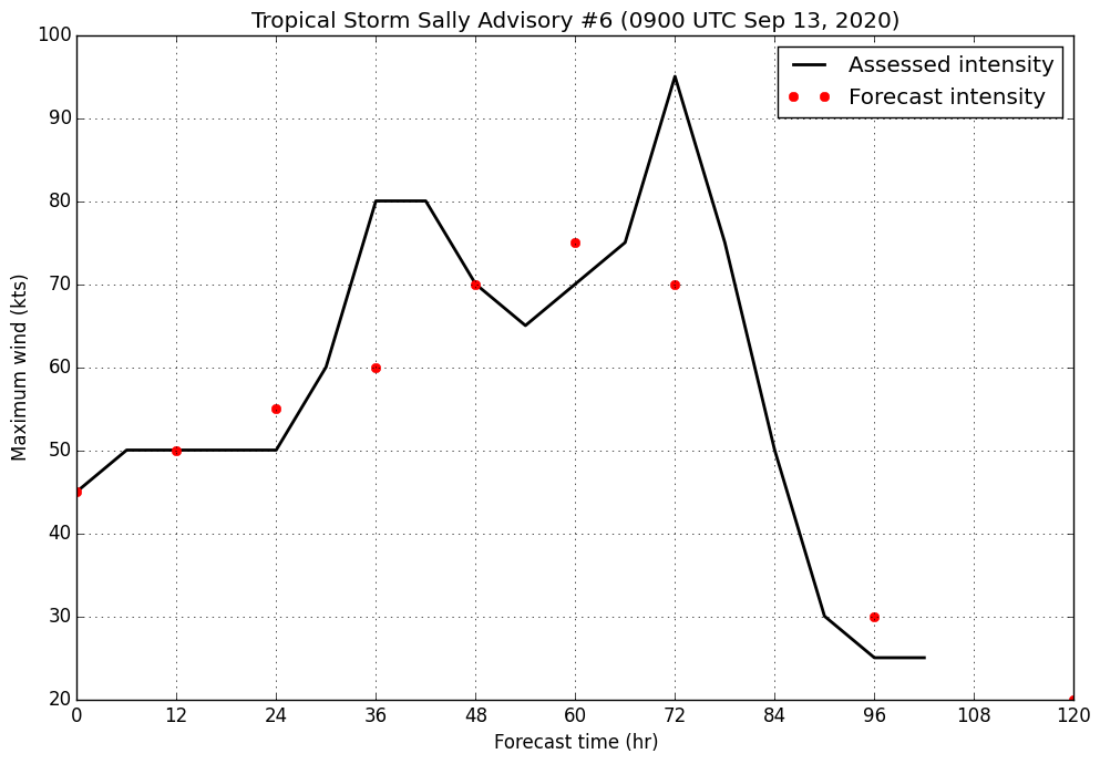
Tropical Storm Sally
Advisory 6 / 5:00 AM EDT Sunday, September 13, 2020
45 kt, 1001 hPa
Sally has strengthened this morning, with new deep convection developing near and over the previously-exposed low-level circulation center as seen on infrared satellite imagery. An earlier Air Force reconnaissance mission into the storm found 55kt FL winds at 925hPa and reliable SFMR winds around 45kt, which support adjusting the initial intensity to 45kt.
Sally continues to be affected by moderate northwesterly wind shear, although this is expected to weaken today as the storm develops a protective upper-level anticyclone. The system will have a favorable environment to strengthen in as it traverses over very warm sea surface temperatures of 29-30C with modest mid-level moisture. Statistical guidance has risen this cycle and support a mid-range category 1 system at landfall, and the intensity forecast has been adjusted upward slightly as a result. Weakening will be swift as the system moves inland as shear increases and the system should degenerate into a remnant low by the end of day five.
Sally continues to track west-northwest this morning, guided by mid-level ridging to its northeast. The storm should continue on this track, slowing gradually as steering becomes weaker with an approaching trough through about 60h when the system should be making landfall in Louisiana and/or Mississippi. The trough and a developing ridge over and just east of Florida will begin to steer Sally toward the north and eventually northeast by day four, a track which it will continue on until the end of the forecast period.
FORECAST MAX WINDS
INIT 13/0900Z 45 KT 50 MPH
12H 13/1800Z 50 KT 60 MPH
24H 14/0600Z 55 KT 65 MPH
36H 14/1800Z 60 KT 70 MPH
48H 15/0600Z 70 KT 80 MPH
60H 15/1800Z 75 KT 85 MPH
72H 16/0600Z 70 KT 80 MPH...ON MISSISSIPPI COAST
96H 17/0600Z 30 KT 35 MPH...INLAND
120H 18/0600Z 20 KT 25 MPH...INLAND/POST-TROP/REMNT LOW
|
|
 |
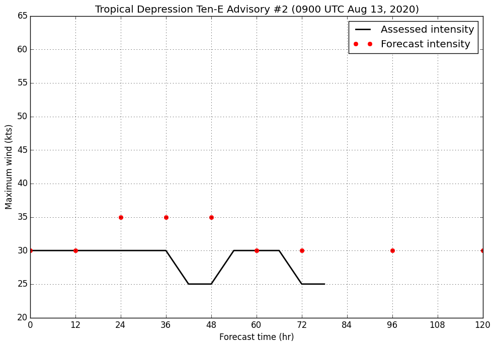
Tropical Depression Ten-E
Advisory 2 / 2:00 AM PDT, Thursday, August 13, 2020
30 kt, 1004 hPa
Convective coverage has expanded around the southern semicircle of Ten-E this morning and subjective organization has increased on infrared satellite. An ASCAT pass found several 30kt barbs surrounding the somewhat elongated but well-defined center. Combined with Dvorak estimates from SAB and TAFB, the depression's initial intensity has been raised to 30kt.
Ten-E exists in an environment of moderate northeasterly shear which is forecast to increase over the next two days to 20-25 kts. The short term appears most favorable for this system, during which it should be able to intensify into a minimal tropical storm in around 24 hours before the shear ramps up and is able to inject dry air into the system. Beyond this point, around day 3, the system is likely to struggle and weaken to tropical depression status where it will struggle to intensify for the rest of the forecast period. It is possible, however, that this environment spells the end of Ten-E and it degenerates into a remnant low sometime beyond day 3 instead.
Ten-E is situated south of mid-level ridging which is forcing the storm west this morning. The system is forecast to meander generally west for much of the beginning of the period, although the confidence in any specific forecast track is minimal at this time. Toward the end of the forecast period, the ridge to the north of the system will erode as a broad cyclonic gyre likely to be associated with a tropical cyclone impinges upon it. Dynamical model guidance at this time suggests that this will result in a slower westward motion in the latter days of the forecast period, with the possibility for Ten-E to stall or even turn eastward, although this is appearing less likely.
FORECAST MAX WINDS
INIT 12/0900Z 30 KT 35 MPH
12H 12/1800Z 30 KT 35 MPH
24H 13/0600Z 35 KT 40 MPH
36H 13/1800Z 35 KT 40 MPH
48H 14/0600Z 35 KT 40 MPH
60H 14/1800Z 30 KT 35 MPH
72H 15/0600Z 30 KT 35 MPH
96H 16/0600Z 30 KT 35 MPH
120H 17/0600Z 30 KT 35 MPH
|
|
 |
| Average forecast intensity error by forecast hour |
| Forecast hour |
12 |
24 |
36 |
48 |
60 |
72 |
96 |
120 |
| Atlantic avg. intensity error (kts) |
6.2 |
8.8 |
11.1 |
12.7 |
14.5 |
13.5 |
16.1 |
18.3 |
| East Pacific avg. intensity error (kts) |
4.8 |
7.7 |
10.8 |
13.0 |
14.6 |
17.0 |
18.4 |
17.7 |